Share Littleton Local Area Traffic Management Plan on FacebookShare Littleton Local Area Traffic Management Plan on X (formerly Twitter)Share Littleton Local Area Traffic Management Plan on LinkedinEmail Littleton Local Area Traffic Management Plan link
Consultation has concluded
Council is developing a Local Area Traffic Management Plan (LATMP) for Littleton to help make the area safer, more accessible, and better prepared for the future. The plan aims to improve road safety, enhance walking and cycling connections, and ensure the local transport network meets the needs and expectations of the community as it grows.
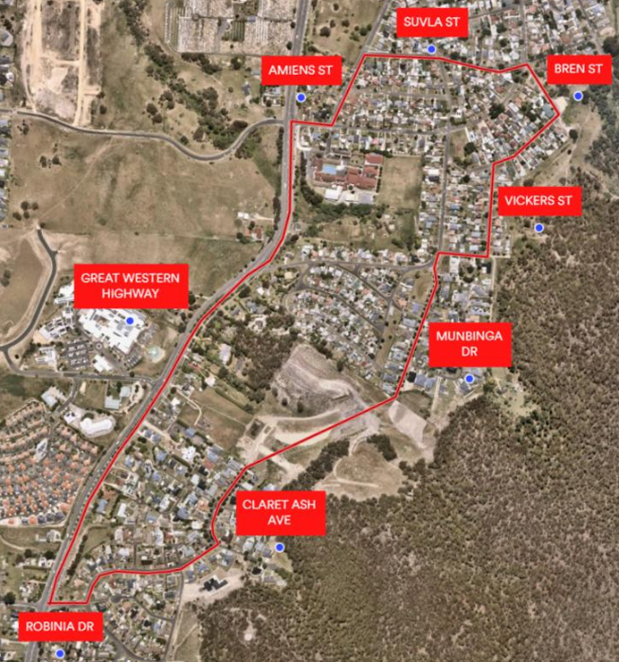
The study area for the LATMP is shown in the map below.
Study Area for the Littleton Local Area Traffic Management Plan: Great Western Highway, Robinia Drive, Claret Ash Avenue, Munbinga Drive, Vickers Street, Bren Street, Suvla Street, Amiens Street.
Council is developing a Local Area Traffic Management Plan (LATMP) for Littleton to help make the area safer, more accessible, and better prepared for the future. The plan aims to improve road safety, enhance walking and cycling connections, and ensure the local transport network meets the needs and expectations of the community as it grows.
The study area for the LATMP is shown in the map below.
Study Area for the Littleton Local Area Traffic Management Plan: Great Western Highway, Robinia Drive, Claret Ash Avenue, Munbinga Drive, Vickers Street, Bren Street, Suvla Street, Amiens Street.
Why Your Feedback Matters
As part of this process, Council is inviting community input to better understand local issues and priorities. Your feedback will help us to:
Identify current safety concerns for pedestrians, cyclists, and drivers
Understand community needs and expectations, now and into the future
Explore opportunities to improve walking and cycling connections
Highlight key issues affecting traffic movement and accessibility
How can I make a submission?
A community consultation session has been scheduled to enable the community to an important role in shaping the future of transport in the Littleton area:
6.30pm on Tuesday, 16th June 2026
Lecture Hall, Charles Hoskins Building, Bridge Street, Lithgow
The evening will consist of a short presentation by the Consultants on why the work is being done, what they've been collecting data on, and then provide an opportunity for the community to bring forward their concerns and discuss some possible solutions that the Consultants can take away and investigate and include in the draft report. It is expected that a final draft of the LATMP will be available for public comment in early September 2026.
 Study Area for the Littleton Local Area Traffic Management Plan: